
How to Use Download for Offline Use

Unit Conversion Table
Field surveyors often juggle between different units—Bigha, Hectares, Square Meters, Gaz, and even obscure regional units. This Unit Conversion Table [HD Image] brings clarity to the chaos. Designed for quick reference, especially on field sites, this table supports: Conversions between standard and local units (like Bigha, Acre, Gaz, Sq. ft., etc.) Gujarati terminology for grassroots field teams A ready-to-use visual format that can be printed, laminated, or viewed digitally Ideal for government cadastral work, land valuation, urban development layouts, and agricultural plots, this table ensures consistency and prevents misinterpretation in measurement-intensive tasks. Link to Download
Various Survey Field Book Formats – Excel
Managing multiple types of surveys often leads to multiple field book formats—each with its own structure and quirks. This Excel resource is a complete package of standardized templates covering nearly all types of field surveying activities. What’s inside? Ready-to-use Excel sheets for DGPS, Drone, Theodolite, Dumpy Level, Total Station, and more Pre-formatted columns with formulas and dropdowns where applicable Space for signature, date, remarks, and calculations Consistent design across formats for smoother team training and report compiling This file is perfect for field teams, students in geomatics, private survey agencies, or government field staff. Use it to reduce documentation errors and standardize your workflow. LINK to DOWNLOAD

Chain & Link Conversion Table
In the world of land surveying, legacy systems often linger longer than expected. One such legacy system is the use of Chain and Link units—once the standard for recording distances in field books and Tippan drawings, especially in older cadastral maps across India. The Chain & Link Conversion Table [HD Image] is an essential reference sheet that allows surveyors and GIS professionals to instantly convert traditional units (like 1 chain = 66 feet or 100 links) into modern metric equivalents. Whether you’re digitizing old Tippan drawings or validating historic land records, this visual aid ensures clarity and accuracy during the conversion process. The table includes: This resource is not just a utility—it preserves the bridge between India’s survey heritage and its digital future. LINK to Download

Field Sketch Book – PDF
Not everything in the field can be described in words or numbers. That’s where sketching comes in. The Field Sketch Book (PDF) provides a blank canvas to visualize terrain, structures, utilities, or unique site observations. Why use this? Draw curves, bends, encroachments, or landscape features Annotate buildings, trees, roads, and landmarks visually Perfect for cross-section drafts, offset recording, and site markups Each page includes space for title, location, date, and remarks It’s an essential tool during reconnaissance visits, property demarcation, or for beginners learning to map. LINK to DOWNLOAD

Leveling Field Book (3-Wire Method) – PDF
When you need the highest precision in leveling, the Three-Wire Method is unmatched. Used primarily in control point establishment and large infrastructure surveys, this format records readings from the top, middle, and bottom wires of the level. This 3-Wire Method Field Book includes: Structured layout for each of the three readings Average calculation fields and final RLs Room for station names, distances, remarks, and closure checks Ideal for dam alignments, long bridges, or rail corridors It improves redundancy and error detection, especially when elevation tolerances are strict. LINK to DOWNLOAD

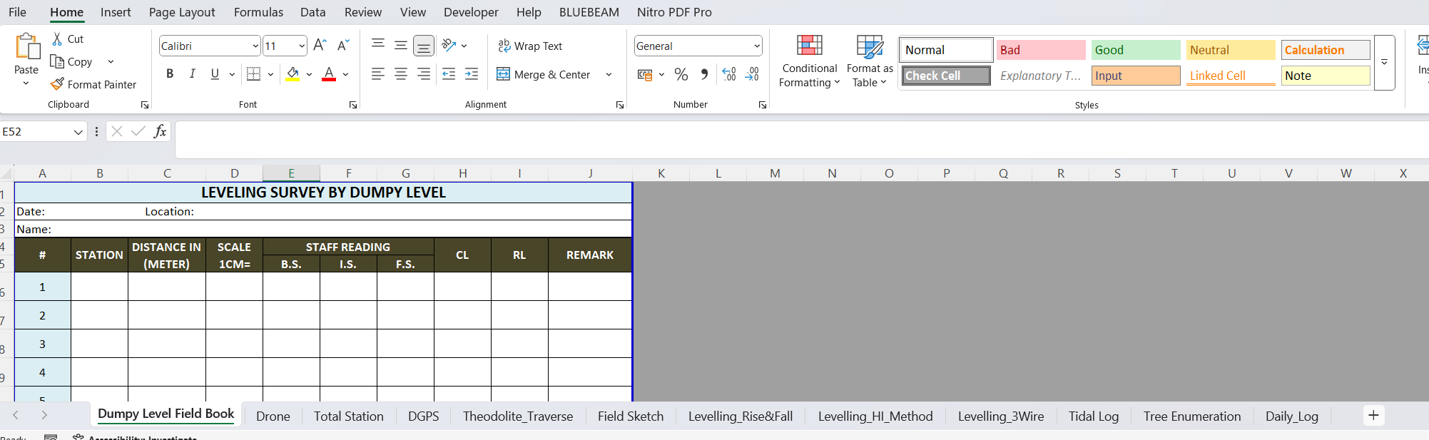
Dumpy Level Field Book
The Dumpy Level remains a reliable workhorse in elevation surveys and is still widely used in construction and land leveling work. But accuracy is only as good as the data recorded. This Dumpy Level Field Book (PDF) provides: Clear columns for back sight (BS), intermediate sight (IS), and fore sight (FS) Running totals and reduced levels (RL) with space for station and remarks Neatly formatted grid to reduce transposition errors Ideal for longitudinal sections, building plinth surveys, and land development Paired with a good leveling staff and steady tripod, this field book enhances the discipline and repeatability of elevation control surveys. LINK to DOWNLOAD

Drone Flight Log Book
Drones have become indispensable in modern surveying, offering faster data collection and access to difficult terrains. However, to maintain regulatory compliance, ensure data traceability, and support project documentation, every drone operator needs a systematic flight log. This Drone Flight Log Book (PDF) is designed for professional drone pilots and survey teams. It includes: Pre-flight, in-flight, and post-flight checklists Sections for pilot and observer details Fields for mission duration, GPS lock, altitude, battery cycles, wind conditions, and fail-safes Notes for remarks and incident reporting It’s perfect for BVLOS submissions, asset mapping, volumetric studies, and government tender documentation. Whether you’re flying for aerial mapping or inspection, this logbook provides the confidence that every mission is traceable and auditable. LINK to DOWNLOAD

DGPS Field Book
When it comes to geodetic-level accuracy, Differential GPS (DGPS) is the gold standard. But even with advanced instruments, proper data logging remains crucial. This DGPS Field Book in PDF format provides: Organized columns for point ID, latitude, longitude, ellipsoidal height Space for PDOP/HDOP values and correction data Signature and remarks sections for each session Ideal for GNSS campaigns, control networks, and high-accuracy corridor mapping Designed by survey professionals for the field, this format simplifies the coordination between operators and analysts. It also serves as documented evidence for submission in government or QA processes. LINK to DOWNLOAD

Daily Field Survey Log Book
Consistency and traceability are key in surveying. The Daily Field Survey Log Book PDF format is designed to record your entire day’s field activity—from time logs to equipment used, location notes, and staff signatures. Each sheet includes: Time slots for morning and afternoon sessions Columns for equipment details, area surveyed, and team members involved Signature blocks for supervisors Notes for weather or disruptions This document serves as a legal record, internal tracker, and audit trail—ensuring field transparency in both private and government projects. It’s a must-have tool for project leads and QA/QC teams. LINK to DOWNLOAD