
When you need the highest precision in leveling, the Three-Wire Method is unmatched. Used primarily in control point establishment and large infrastructure surveys, this format records readings from the top, middle, and bottom wires of the level. This 3-Wire Method Field Book includes: Structured layout for each of the three readings Average calculation fields and final RLs Room for station names, distances, remarks, and closure checks Ideal for dam alignments, long bridges, or rail corridors It improves redundancy and error detection, especially when elevation tolerances are strict. LINK to DOWNLOAD

Dumpy Level Field Book
The Dumpy Level remains a reliable workhorse in elevation surveys and is still widely used in construction and land leveling work. But accuracy is only as good as the data recorded. This Dumpy Level Field Book (PDF) provides: Clear columns for back sight (BS), intermediate sight (IS), and fore sight (FS) Running totals and reduced levels (RL) with space for station and remarks Neatly formatted grid to reduce transposition errors Ideal for longitudinal sections, building plinth surveys, and land development Paired with a good leveling staff and steady tripod, this field book enhances the discipline and repeatability of elevation control surveys. LINK to DOWNLOAD

DGPS Field Book
When it comes to geodetic-level accuracy, Differential GPS (DGPS) is the gold standard. But even with advanced instruments, proper data logging remains crucial. This DGPS Field Book in PDF format provides: Organized columns for point ID, latitude, longitude, ellipsoidal height Space for PDOP/HDOP values and correction data Signature and remarks sections for each session Ideal for GNSS campaigns, control networks, and high-accuracy corridor mapping Designed by survey professionals for the field, this format simplifies the coordination between operators and analysts. It also serves as documented evidence for submission in government or QA processes. LINK to DOWNLOAD

Daily Field Survey Log Book
Consistency and traceability are key in surveying. The Daily Field Survey Log Book PDF format is designed to record your entire day’s field activity—from time logs to equipment used, location notes, and staff signatures. Each sheet includes: Time slots for morning and afternoon sessions Columns for equipment details, area surveyed, and team members involved Signature blocks for supervisors Notes for weather or disruptions This document serves as a legal record, internal tracker, and audit trail—ensuring field transparency in both private and government projects. It’s a must-have tool for project leads and QA/QC teams. LINK to DOWNLOAD

Tree Enumeration Data
Urban forestry, plantation management, and ecological assessments all begin with data. The Tree Enumeration Field Book offers a clear format for recording: Species, girth at breast height (GBH), tree height GPS location, health condition, and ID number Notes on flora diversity and replantation It’s ideal for smart city planning, green audits, environmental clearance, and heritage tree documentation. LINK to DOWNLOAD
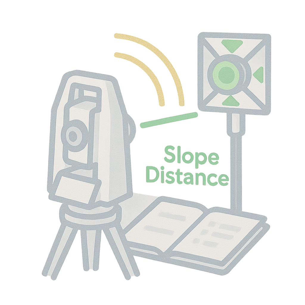
Total Station Field Book
The Total Station Field Book is your partner for modern surveying needs. Whether you’re recording topography, layout points, or control networks, this PDF simplifies data collection in the field. What’s inside? Columns for Station ID, Prism ID, horizontal & vertical angles, slope distance Space for setup details, instrument calibration, and benchmark reference Notes and sketches to aid post-processing in CAD/GIS This book supports everything from small layouts to 100-acre surveys with topographic detail. LINK to DOWNLOAD

Theodolite Traverse Field Book
Traversing is the backbone of many land surveys, and the Theodolite is the trusted instrument for measuring angles with high precision. This field book offers a clean and consistent way to record traverses. Key features: Columns for station name, angle measured, bearing, and distance Traverse adjustment and error closure fields Suitable for property boundary surveys, road centerlines, and bridge alignments Compatible with plotting and CAD post-processing By capturing clean angular and linear data, this book ensures your traverse network is mathematically sound and geometrically tight. LINK to DOWNLOAD
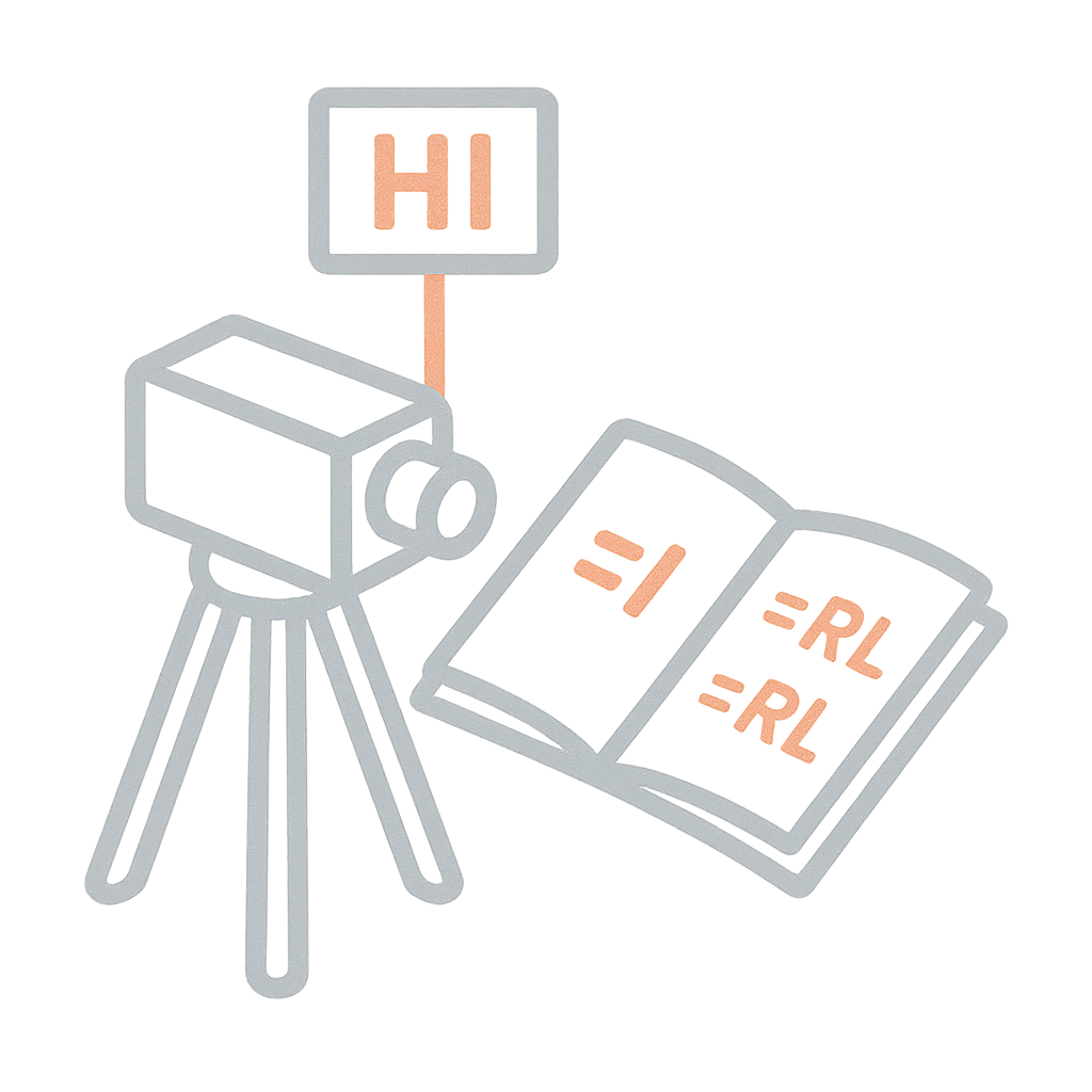
Leveling Field Book (Rise & Fall)
The Rise and Fall method brings clarity to undulating terrain. It allows surveyors to explicitly note how the ground level is changing between points, making it perfect for grading, contour mapping, and road design. This PDF template offers: It supports better decision-making in land development and drainage alignment projects. LINK to DOWNLOAD
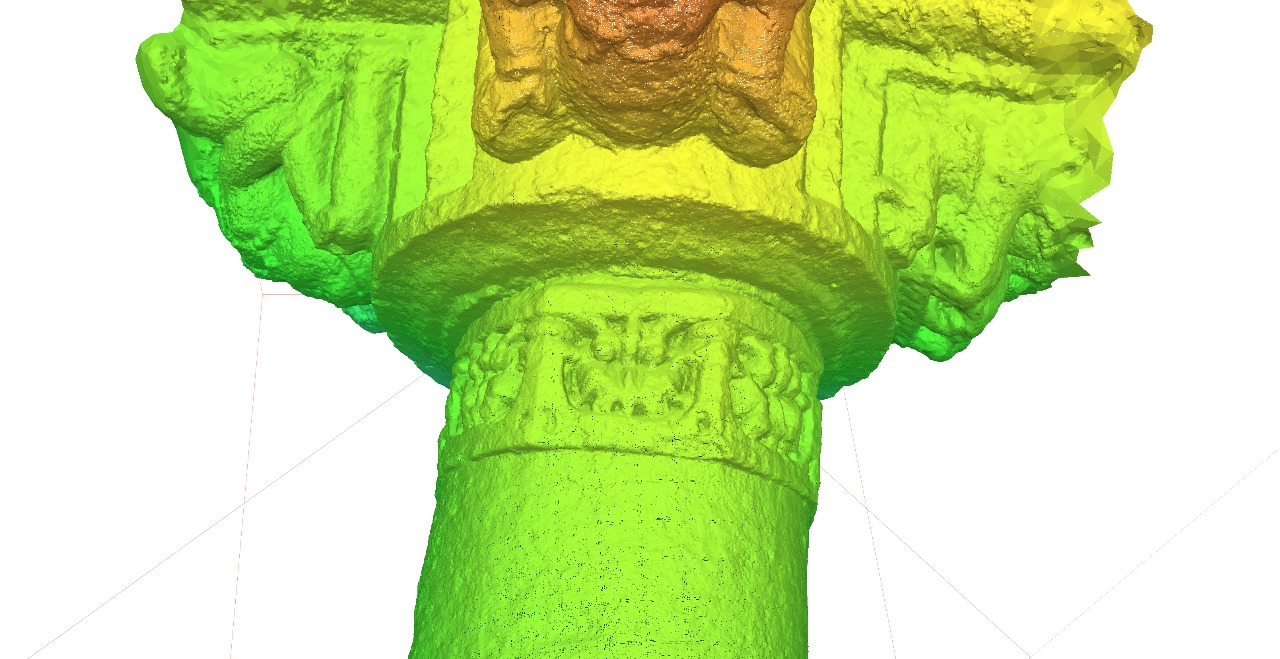
LiDAR Scan for Heritage Site
Last week our team at Trishunya spent just few days scanning a heritage site that normally takes weeks to document by conventional means. We utilized hand-held lider for micro details scanning. (to get details of carving on stone) Why it matters:

Structural Alignment Inspection Project
We’re excited to announce that Trishunya has been appointed as the Structural Alignment Inspector for the Adani Group at the Sardar Vallabhbhai Patel International Airport, Ahmedabad ✈️ Our responsibilities include high-precision third-party inspection and verification of column alignments, wall foundations, and the complete structural layout of the work executed by PSP Projects Ltd. We ensure that every structural element is executed in strict conformance with the approved drawings and design, maintaining the highest standards of accuracy and compliance. We’re honored to contribute our expertise in layout validation and structural integrity to one of India’s most important and future-ready airport projects.