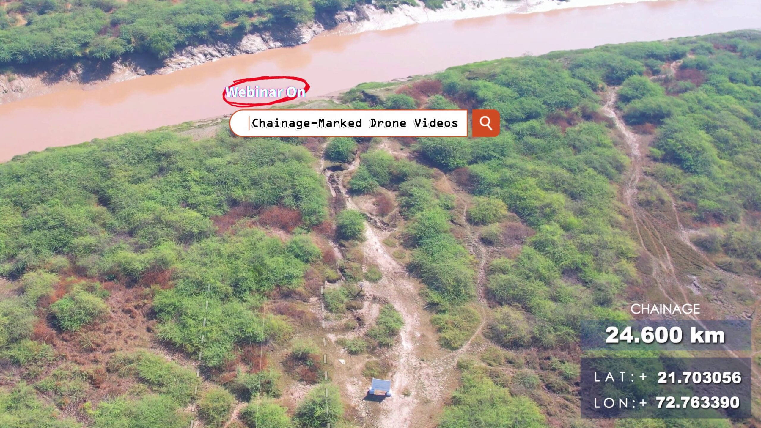
Learn how to turn your corridor drone videos into powerful tools with chainage labels.📌 Topics Covered:✅ Drone camera angle & flight plan tips✅ SRT telemetry from drones✅ Chainage calculation using GPS logs – Free Script & Tool✅ Overlaying chainage text on video – Video Editing Tips ⚙️ DRONE SRT to CHAINAGE AND OTHER SRT COVERTER TOOL :🔩 https://bgol.in/2025/09/20/tool-chainage-marked-drone-videos/ Other Links:⦿ Math – Haversine Formula: https://en.wikipedia.org/wiki/Haversine_formula⦿ Flight Visualizer: https://djitelemetryoverlay.com/srt-viewer/ ⦿ Camera Telemetry Creator: https://goprotelemetryextractor.com/drone-heads-up-display⦿ Video Editing Tool: https://filmora.wondershare.net/⦿ Google Earth: https://www.google.com/intl/en_in/earth/about/versions/⦿ Dronelink: https://www.dronelink.com/ Connect with me: https://www.linkedin.com/in/thevijayparmar/ Join BGol Community: https://bgol.in/register
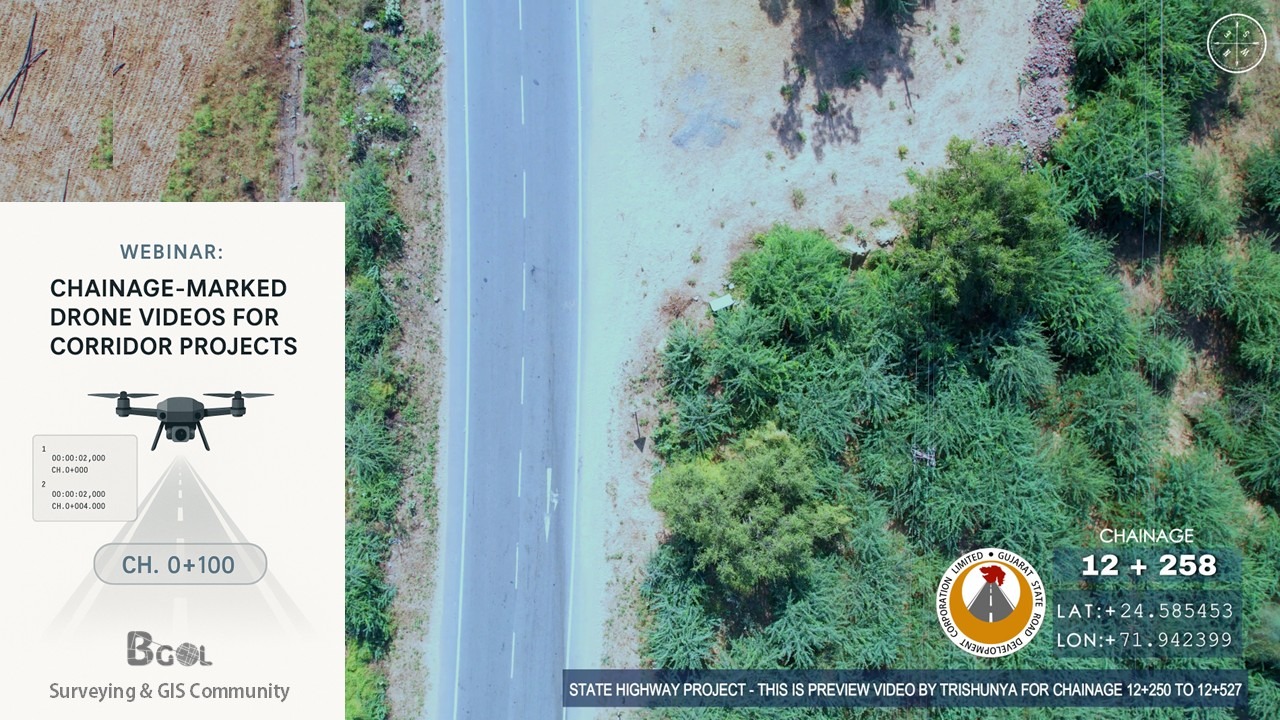
Tool – Chainage-Marked Drone Videos
This app could not be embedded due to browser/security settings. Open DJI Chainage Extractor (opens in a new tab) Drone Chainage & SRT Processing A Streamlit application that automates extraction and processing of GPS metadata from DJI drone video .srt files, generates chainage markers along a reference alignment (KML), and produces synchronized SRT outputs and 3D visualizations. 🚀 Purpose 📋 Features & Workflow 🔍 Under the Hood: Mathematical Background 1. Haversine Formula Computes great‐circle distance between two GPS points (φ1,λ1) and (φ2,λ2): Δφ=φ2−φ1,Δλ=λ2−λ1,a=sin2(Δφ/2)+cosφ1,cosφ2,sin2(Δλ/2),d=2Rarcsin(a), where: 2. Cumulative Chainage Given points P0,P1,…,Pn: Ck=∑i=1kd(Pi−1,Pi), where d() is the segment length from Haversine. 3. Regular Interval Markers To place markers every Δ km:
Marketing – Contact Trishunya for Land Surveying Projects
Trishunya Survey Solutions: Elevate Your Project with Unmatched AccuracyFrom urban master plans to coastal hydrography, Trishunya delivers turnkey surveying services—combining GNSS, LiDAR, drone photogrammetry and total-station precision to turn complex terrain into clear, actionable data. Whether it’s grading an airport runway or mapping a new township, our expert team ensures on-time delivery, rigorous QA/QC, and CAD-ready outputs that integrate seamlessly into your workflow. Visit Website Today: https://trishunya.com/ BGol Profile: https://bgol.in/user/trishunya.consultancy/

Portfolio – Trishunya 2.0
At Trishunya Consultancy & Infrastructure, our surveying expertise is showcased through a diverse portfolio of critical projects across Gujarat: Urban & Municipal Surveys: Detailed topographic mapping and corridor investigations for the Bhavnagar Municipal Corporation in Bhavnagar, Gujarat Port & Coastal Works: Precision hydrographic and structural surveys for APM Terminals at Pipavav Port, ensuring safe navigation and infrastructure planning Energy & Utilities: Comprehensive pipeline route and right-of-way assessments for GETCO in Dholera, Gujarat, supporting seamless power transmission Each engagement combines cutting-edge GNSS, LiDAR, drone, and total-station technologies with rigorous QA/QC procedures to deliver accurate, actionable data. Explore our full portfolio at www.trishunya.com and discover how we can bring precision and reliability to your next surveying project.

Portfolio – Trishunya
At Trishunya, we turn complex terrain into clear, actionable data—leveraging GNSS, drone photogrammetry, LiDAR and total-station workflows to support infrastructure, urban planning and water-resources projects across Gujarat. Portfolio Highlights: Science City, Ahmedabad: 3D terrain models & high-res topography Canal Works: As-built alignment checks & gradient analysis Transportation: Runway grading, platform elevation surveys

Drone Flight Log Book
Drones have become indispensable in modern surveying, offering faster data collection and access to difficult terrains. However, to maintain regulatory compliance, ensure data traceability, and support project documentation, every drone operator needs a systematic flight log. This Drone Flight Log Book (PDF) is designed for professional drone pilots and survey teams. It includes: Pre-flight, in-flight, and post-flight checklists Sections for pilot and observer details Fields for mission duration, GPS lock, altitude, battery cycles, wind conditions, and fail-safes Notes for remarks and incident reporting It’s perfect for BVLOS submissions, asset mapping, volumetric studies, and government tender documentation. Whether you’re flying for aerial mapping or inspection, this logbook provides the confidence that every mission is traceable and auditable. LINK to DOWNLOAD

Faculty Training on Drone Technologies for Construction
We recently had the privilege of conducting a Faculty Development Training (FDP) at Parul University, aimed at bridging the gap between traditional teaching methods and the rapidly evolving landscape of aerial surveying, GIS, and AI-powered civil engineering solutions. 🔍 Key Focus Areas:Introduction to Aerial Intelligence – Understanding how drones and smart payloads are revolutionizing topographic surveys, infrastructure monitoring, and construction planning. AI Integration in Surveying – Showcasing real-world applications of AI for crack detection, volumetric analysis, and 3D reconstruction using NeRF (Neural Radiance Fields). Hands-on Demonstration – Live demos and post-processing workflows gave faculty members a direct experience of how modern tools can enrich both research and teaching. The session was not just about tools and technology—it was about equipping educators to guide the next generation of engineers with real-world, field-tested knowledge. We extend our thanks to the Department of Civil Engineering, Parul University for hosting us and fostering such a forward-thinking learning environment. The curiosity and participation from the faculty reaffirmed our belief: when educators are empowered, the ripple effect reaches generations of learners.
Training on Advanced Surveying to Govt. Officials
🧭 From ground control to 3D models – we trained them on it all!” Proud to be a part of a training week at WALMI, Anand, where we introduced government officers to the future of Advanced Surveying using Drone Tech. ___________________ Thanks to Trishunya Consultancy and our knowledge-sharing platform BGol Community, we could deliver real hands-on value – not just presentations. We walked participants through: Looking forward to more such impactful training!